Earthquake Hits Philippines’ Luzon Island, Rattling Manila
By Staff, Agencies
An earthquake has hit the northern Philippines, shattering windows at its epicenter and causing high-rise towers to shake more than 400km away in the capital Manila.
The quake, which struck the mountainous and lightly populated province of Abra on the main island of Luzon at 8:43am local time on Wednesday, was measured at a preliminary magnitude of 7.1 by the US Geological Survey [USGS], 7.2 by the European Mediterranean Seismological Centre [EMSC] and 7.3 by the Philippines Institute of Volcanology and Seismology [Phivolcs].
Phivolcs later revised the magnitude down to 7.0, but the quake is the strongest to have hit the Philippines in years.
President Ferdinand Marcos Jr, whose home town is in the northern Philippines, ordered rescue and relief teams to be sent to Abra, and is preparing to fly to the affected area, Press Secretary Trixie Cruz-Angeles told a news conference.
USGS said the earthquake’s epicenter was about 11km east-southeast of the town of Dolores.
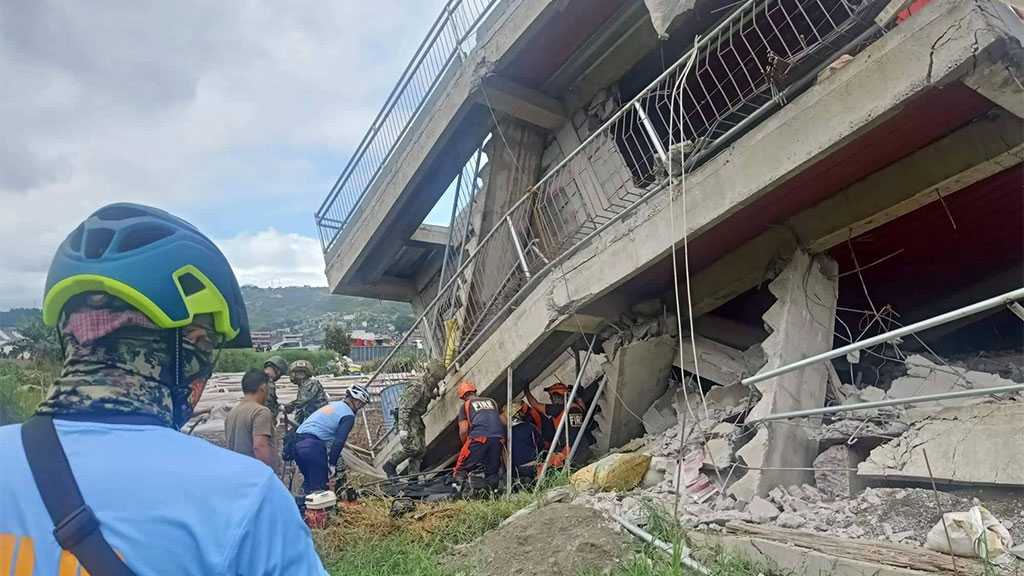
Pictures shared on social media by local officials and residents showed some buildings collapsed into rubble with others leaning precariously, their windows shattered.
Some cars were crushed by the debris and roads left crumpled and damaged. Officials also reported some landslides.
There were no immediate reports of casualties.
Police Major Edwin Sergio told the AFP news agency people in Dolores ran outside as the earth shook.
“The quake was very strong,” Sergio said, adding there were minor cracks in the police station building.
“The earthquake lasted 30 seconds or more. I thought my house would fall,” Eric Singson, a congressman in the northern Ilocos Sur province, told DZMM radio.
“Now, we are trying to reach people. … Right now, there are aftershocks so we are outside our home,” he added.
Elsewhere in Abra province, a hospital was evacuated after the building partially collapsed.
In Vigan City, in the nearby province of Ilocos Sur, centuries-old structures built during the Spanish colonial period were damaged. Video shared on Twitter and Facebook showed the city’s Bantay Bell Tower beginning to crumble as onlookers flee.
The Philippines Red Cross said its teams on the ground were assessing damage in the affected communities.
In Manila, service on the city’s metro rail systems was temporarily suspended after the earthquake, while the Senate and many high-rise office buildings and residential towers were also evacuated.
People in Manila were allowed to return to their homes and offices after they had been checked by officials.
The Philippines is located on the Pacific ‘Ring of Fire’, a 40,000km arc of intense seismic activity that stretches from Japan through Southeast Asia and across the Pacific basin.
In October 2013, a magnitude 7.1 earthquake struck Bohol Island in the central Philippines, killing more than 200 people and triggering a number of landslides.
Nearly 400,000 people were forced from their homes as a result of the disaster.
Comments
- Related News